Winter v3: Hot and Snowy

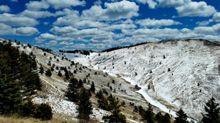
Coming up the slopes of Mt. Taylor in NM was the first snow I hit on the CDT. I’d been hiking with a pair from England; we briefly considered getting an early start before an overnight storm brought rain to our camp, but a fresh dusting above the treeline. If we hadn’t been able to see the snow up there when it was still many miles ahead you would’ve hardly expected as much snow coming up from the hot desert and El Malpais of the past section.

The San Juans were like a fully self contained winter that we just wandered thru betwen mid May and early June; save for the warm air temperatures. I had plenty of days where Snuffles and I seldom stepped off the snow, and barring the wind we probably would’ve wanted to wear shorts most of the way too.

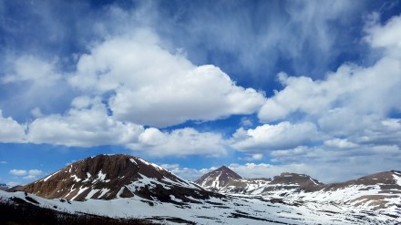
A view from Boulder pass, last year when I was still heading West I was maybe a little early for this route thru Glacier National Park, and there were a few more steepish snow traverses than I would’ve wanted. I’m excited to get back there in a few weeks. It was hot then, and its hot now, but I wonder how much snow will be left on the trail. I only recently broke my streak again, this time thru ID was the first state since ND without any snow. 

Advertisement

Sculpture v2: Unexpected, Unexplained.

This little piece of enigmatic metalwork is somewhere on the PCT just South of Casa de Luna, nobody (by which I mean me) knows why its there. At first glance it appears to be an arrow, maybe pointing in the direction of trail, however it is not at a junction and points 30 degrees off trail into a bush. In addition, the fletching is off, leading me to believe that it was meant as a conjunction of the Venus (♀) and Mars (♂) symbols. (it could also be Mars and the modern Earth symbol {♁} but that seems unlikely to me) These symbols in a modern context are often used to refer to gender, and their orientation in this sculpture is rotated, so I think the Artist intends for us to flip gender on its side…?

This may not count as sculpture if your conceptualization of sculpture requires a human artisan, but mine does not and this is the spitting image of an eagle anyway. Eagle Rock is a fixture of the PCT, such that I knew it was coming up, and I had only seen about 3 people on trail (not counting 100 yards from roads, and even including them its not many) in the last 1200 miles of the PCT.

These ended up being on a dead end spur, (I briefly headed towards Los Vegas for a doomed attempt to meet up with Mammoth for a third time.) but a pair of (shī) randomly off route 66? What in the world? They’re just in the desert; they even have registers despite not being on a trail, but no explanation.

Animals on the Trail v3: Desert Dwellers

This friendly coyote just wants the food I keep on my shoulder straps. The National Parks are a sort of haven for tame animals, assuredly a result of being fed by tourists and seldom hurt by people. Death Valley in particular had many animals willing to approaching well within my comfort zone; however I got the best picture of this coyote, which was one of three I saw pretty close, and a small fox, maybe even a kit!

The Salton Sea is one of the stranger landscapes I have traversed, lined with fish bones and chitinous barnacle shells leave the beach a surreal sort of hellscape, wherein it is consistently possible to sink up to your calves in bleached dry bone. The lake itself smells off, a cross between the ocean, an urban riverfront, and the sulfur springs of a volcano. in the transition area between the water and the fields of organic decay, a small sand bar filled with sea birds, obviously attracted to this large inland body of salt water.

Buzzards circling some expanse, is a little less common than westerns might lead you to believe. I didn’t go near the epicenter to see whose wake these vultures were attending; most likely roadkill, of which I do not shy away from, but it certainly does not draw me in. This guy kinda looks like he is doing an impression of unpopular opinion puffin.

A little horned lizard hiding away in the Northeastern section of Joshua Tree NP, he’s kinda hard to see, but don’t hold it against him; that’s how he stays alive. There was a bit of rain and general humidity relative to the normal desert clime, so the greens have been really bright, but that’ll probably taper off in the coming weeks.

Winter v2: Frozen Deserts

Overall, winter seems to only come in a few flavors on trail. Some such as while crossing the Inyos for this look into Saline Valley, are amongst my favorite hiking conditions, and it might be a stretch to even call them winter. Cool air, comparatively warm sun. I’ve said it before, but this kind of weather inspires big mile days more than any other.

Similar weather abounded in the desert sections of the PCT, especially after I came down from the high points near San Jacinto and Onyx Peak; where conditions dipped into another flavor of trail winter, too windy and wet to stop and fiddle with Cameras. Luckily it didn’t stay that way for too long. The overarching plan to spend winter in the Southwest is working out, almost too well. Its maybe a bit hot for me at these lower elevations.

Herein upon Muir Pass I having had a bit of this second flavor of winter, but was also determined to try to photograph my surroundings. It helped that I could hop in and out of the Muir Pass Hut for refuge as need be.

Another, more literal flavor of winter camping is while snow may not be present, temperatures are low enough that you can pack ice cream out from town for you first breakfast. I would encourage this universally, everyother non-cooked meal you eat will already be equally cold.

Gear sprawls v4: A Yardsale in Review

big

As I am getting back on the PCT post-holiday break it seems that I may have made the wrong choice with regards to weather. Had I stayed on trail I would have finished out SoCal without much trouble, but it seems we’ve caught a few decent storms since then, so I’m coming back in with a pretty similar kit to what I carried thru the Sierra, basically just minus an Ice Ax. Carrying the snowshoes unnecessarily feels a little silly, but I think I may get some use out of them given how low snow line is on San Jacinto.

worn

Although, my kit doesn’t change that much season to season, I try and keep my budget a little too tight for that. Most of this stuff has come a long way, and my use conditions for this trip put a bigger premium on durability (or warranties) than I would if I were doing a single trail. Both puffy jackets were acquired on trail, although the top one I picked up on mile 40 o the AT… the second is perhaps a bit overkill now, I’ve only worn them together a couple times. (namely atop Mt. Whitney) While keeping weight down is important, preventing gear failure (especially in winter conditions) is paramount; both from a sense in that if I am carrying it, then I need it to be not broken, and in a sense that replacing gear cuts into the coffers, which ultimately will be what forces me off trail.

unworn

The red and silver sleeping bag liner is a vapor barrier, which really does extend the range of comfort. Although I already sleep quite warm, and early in the trip found that my 20°F bag I could sleep comfortably into the teens. This has since receded a bit as I think I may have worn or otherwise damaged the down. Despite washings it never seems to recover its original loft, it is however still quite warm, and with VBL layers and some midnight crunches I haven’t found too much trouble sleeping below 0°F. Also of note slight modifications to my tent, having added a set tension distributing guy lines, I reduced the number of stakes required for setup by 4, bringing minimum setup to 4 stakes and fully battened down at 6 stakes. I recently modified it further. Using some small plastic rings cannibalized from my backpack, to minimize the cord on cord action, which should prolong the life of the guylines a bit.

Roadwalkin’ v1

Ever maligned, often deservedly so. Road sections have something to offer, especially if you count making peace with the death that speeds past, not but an arms length away.

In the final section of the NCT, while following the ill fated McClusky Canal; ya gotta take what elevation change you can, and this ten foot embankment is about it.

Finding a roadwalk route from Lake Sakakawea to Glacier NP isn’t too hard, but a little effort and some extra miles to get you off of US2 in Eastern MT is worth it. Even if you do see the rockies for an extra day before reaching them.

The Joys of having left the plains, to the point where turning around yeilds a view to Chief Mountain, instead of the seemingly endless horizons.

Crossing 138, (not walking along it… I know) into Crater Lake NP, even the road caught some of the sunset’s reflection. Climbing Mt. Thielsen that afternoon put me behind enough to catch this here, rather than somewhere in the forest without a clear view to the skies.

Architecture v2: Unaccompanied Miner’s Equipment

Second to last stop before catching the PCT. Camped out in an abandoned miner’s cabin, thatvhas since been refurbished for recreational use. The Map said it was a Tungsten Mine, and being on the side of Wolframite Mountain seems appropriate. There was quite a spread of old heavy machinery strewn about, I spent a couple hours photographing, and didn’t even check it all out! Deserves another trip honestly.

Eby’s Stamp Mill, across the river from Belden, CA and just along the roadside. Used to Process Gold from ore, now its mostly a nice place to have a roadside picnic. Complete with privy.

A saw measured for cutting square-set timbers, for the Comstock Lode in Virginia City, NV. I got to take a short side trip out there from South Lake Tahoe with one of the women who was also staying at the hostel there.

Saline Valley Salt Tram Crossover Station. This used to be the top of a system of Gondolas that could transport people and salt from Saline Valley (just west of Death Valley proper, and inside the National Park) to the Owens Valley, and thus the rest of California. In the brief research I did for this I feel like I should’ve poked around a bit more, I was in quite a hurry to badwater though. Will return here aswell.

Gear Spawls v3: Unsprawled in Shelters (because thats rude.)

This week comes with some extra pictures, since I messed up last weeks post.

Benson Hut, just a little south of Donner Pass on the PCT. The shelters out west don’t get the love they do on the AT, but they are generally super nice. Combining unique construction and eclectic feature sets, I dunno why most thru-hikers out here aren’t super pysched on them…

A little old gem in the Pasayten Wilderness, I didn’t end up staying here, but despite the disrepair I could see myself doing so. Its got bunks, a dirt floor, and a tree on the roof, what’s not to like? Elmo was still keeping up with me fer this one, but the PCT and TK were almost in sight and I was getting a little over-excited to do high mileage.

Not the shelter I stayed at, but Lakenenland had a little adirondack shelter out back, complete with cots, a table, and full window exterior doors. This little picnic shelter makes a better picture what with the sculpture an all. Also I don’t seem to have a picture of the actual shelter…

Boots on the Ground v2: Boots on the Snow

From the top of Mt. Wynne, only a few days ago. You can see Pinchot pass is pretty clear, but unfortunately the trail is enough of a rut that it has protected the snow, leading me to still be snowshoeing on about 4 to 6 inches of snow, when about half the surrounding ground is clear… that horizontal line of snow on the left about in the middle is the trail down.

A sign atop Donahue Pass on the south border of Yosemite NP, I don’t know how tall it is, but looking back to that last significant snowfall we’ve gotten a lot of melting don in the past couple weeks.

Right around shasta we got a little bit of snow, just enough to make climbing Shasta inadvisable. but in the following days I found quite a few tracks thru the remaining snow. this one seems to have stuck around a ways after the snow it was made in melted away. Such is the power of dirt.

Here’s my pruned foot, neither in a boot nor on snow.

Near Crater Lake I got my first snow of the PCT, and did a fair chunk of trudging. This was the second day of constant wet feet, and it shows a bit. Got to stop in at South Brown Mountain Shelter, build a fire and dry out. Some  of those divots didn’t really go away with the wetness though.

Animals on the Trail v2: little guys

Preying mantis in NorCal, I’d never seen one in real life. They look super cool, I dunno if it was cold, or something else, but it seemed unable to move significantly. Nice for photos, not so much for its survivability, especially given its right in the middle of the trail. I even passed a NoBo 15 or so miles past who might be the one to spell its doom. Hope you can make it outta there little bug buddy!

This finger sized frog hanging out on a privy seat in ND, I usually avoid picking up little animals, but he was chilling out pretty hard and I wasn’t really looking to sit on him, or wait for him hop off on his own. I see a lot of toads, and hadn’t seen many frogs, atleast not since I was in the southern AT. Then they’d been mating, you could hear the frenzy of croaks for a quarter mile in either direction!

This big ol’ Beetle (?) was trying to roll this rock around ID, wasn’t making much progress, but I sat and watched him try for a few minutes. Kinda wonder why it was so intent on this little stone, probably something mundane, yet nefarious. 

Tiny Spider crawling around some asphalt near an earthen dam in OH, might’ve posted this one on the previous iteration of the blog, but it wasn’t till now that I noticed the the thin thread of silk being spun behind it.