The Way Back.

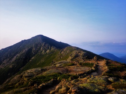
Returning to trail after finishing the AT was at once wonderful, and very melancholy. Taking my time and sparing no side trail I worked my way through the hundred mile wilderness much slower than before, taking eight nights to my previous run’s two. I was able to help out a couple south-bounders just starting out, gave one some food after he ran out near the end. In the course of a day I found about four thirds of a trekking pole, for a complete extra, (It was even a carbon fiber pole with flick-locks!) only to find someone who had snapped a trekking pole. I had matching parts so I fixed their pole on the condition that they carry out the broken pole sections I had packed up while scavenging out their replacement sections. The hundred mile wilderness is one of the best sections of the AT, (VT to ME is the best quarter of the AT in my opinion) and if you know where to look there are a couple AMC huts that gave me pretty easy work-for-stays even. The other side of the return trip, is that every time I meet up with one of my friends I had passed, it’ll probably be the last time we see one another. All the registers are filled with the parting thoughts from  friends since finished, many of whom I had missed entirely. I certainly had a longer good-bye to the AT than was I was immediately ready for. (Although, looking back on it I remember it very fondly, but at the time it was bittersweet.)

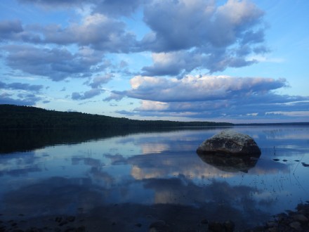
Managed to serendipitously run into Desolation Row, and Baby Blue. The second father child pair, (two twelve-year-old kids did the AT in one year. So no excuses if you really wanna do it.) this time the twelve year old in tow was his daughter, we swam in one of the hundred miles’ many lakes and caught up for a while. Also met Little Bird, whom I had briefly met on my way North. She had attempted a thru 2 years prior, and broken her wrist, she came out the following summer to finish and caught Lyme’s disease. This year she was finally going to make it. She lives on the North Country Trail (NCT) so she’ll come up later on.

wp-1468367121051.jpg

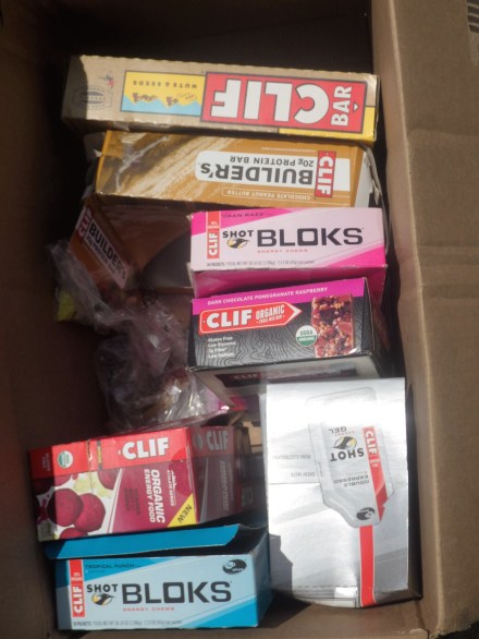
SoBo out of the hundred I stayed at Shaw’s, and for quite a while, there was a bit of ration difficulty. I had a resupply box sent there for me to pick up on the way north, but since my parents met me earlier I had no need for it, and resolved to use it on the return trip. The resupply never showed up, it should’ve been there even a week or two before. I waited a couple days, (The town vortex at Shaw’s was strong, and I got along pretty well with Poet and Hippie Chick) then caught a ride out to a decent grocery store for a real resupply. Getting a hitch back took a while, but it was worth it, I ended up getting picked up by a 2002 thru-hiker, Machine, after hiking he’d become an organic farmer, and hooked me up with a whole bunch of fresh veggies! Lots of beans, peppers, and celery. I read Orange is the New Black, (found in the hundred miles) watched the Perseids and in general just relaxed a lot, dropping to about 20 miles per day before finally making Stratton, ME where I would drop from the AT and cut west for the north end of the LT. Changing my life style into Road walk, stealth camping, and getting eyed by the border patrol agents zooming around.

Advertisement

The End of All Things.

Or: in which I finish the AT and get melodramatic about it.

North of the Mahoosucs ME is pretty easy, the Bigelows are there but aren’t a significant challenge what I’d already gone up against, and it was getting time to speed back up. I was Getting into ME when a lot of the SoBos were getting out, and I gave them some (hopefully) good advice when we met, but for the most part, if they were making it outta ME, they’d probably be fine getting to GA. Managed to pass off the copy of The Hobbit I’d picked up in VA to a SoBo who said she’d try and drop it significantly farther South so it could keep bouncing around the trail. Book-wise, I’d moved onto Siddhartha by Herman Hesse, an Author who I’ve found myself reading in the wilds on more than one occasion, as for my thoughts on it, in a word, great. Easily my favorite new book I’ve read on trail so far, (speaking from MT a year later.) and I would recommend it to anyone who is searching their person, or the world for something.

My parents, almost as excited as I am about my antics on trail had decided to meet me in ME for the end and a day or so of rest. (… and to try and set up this blog, didn’t work out all that well, took till this past May to actually get things set, and I’m only a month in so who knows if this is fully set[fingers crossed here]) Best of all, they brought their dog, and my cat along for the ride, both of whom handled the trip surprisingly well, and I was very happy to get to play with my cat Athena. Only problem with this arrangement however, is that I was behind schedule, by a fair bit too. They we able to extend their time out here and disperse trail magic (homemade brownies, chocolate chip cookies, and whole milk!) for other hikers as they got into slackpacking me northward. This really picked up my pace, and I was able to three day the hundred mile wilderness as a result. This lead to my longest day so far (and somewhat unlikely to be surpassed…), Jo Mary Rd in the hundred miles, to Katahdin, and back to Katahdin springs campground, for about 62 miles.

Nearly everything went my way for that final push, little in the way of elevation, a full moon to climb Katahdin by, and clear skies the whole way up. On a mission, I wordlessly passed the last few shelters filled with hikers in various stages of sleep. Made my way into Baxter, gave a token effort to find a register before heading up, and started the climb. Katahdin is maybe the most significant elevation gain on the whole trail, and it shows as you climb inadequate ladders of rebar, and hoist yourself up the rocks chasing the trail ever higher. A half hour or so after reaching the tree line the moon had begun to set, and I was strictly on headlamp for actionable light. Moving as if dreaming, “surely, the tablelands can’t be much farther…” I would repeat to myself. Finally the sky began to brighten, as I was just on the cusp of the tablelands: I had not walked all this way, from Georgia, through this night, to have set my eyes on a summit sunrise and fail. Reaching the table lands as the deep black of night turns navy and the yellows and oranges bound up from the peripheral horizons as if jeering me onward. Half stumbling, half running, till I could faintly see the sign that marks the Appalachian Trail Terminus, Looming over the last bit of elevation before the end, twenty-one hours and 57 miles of hiking since I had started the morning before.

I had made it.

Fiddling around so I could take a good picture of me on the sign took forever, angling a camera between a rock and a jacket so you can climb a sign in amid decent gusts is hard work, especially when you are already tired. I ended up spending about an hour and a half at the aerie by my lonesome, not quite ready to be done, not quite ready to get back to walking. When the sun was firmly in the up position I began to head down, meeting other thru-hikers all the while put it in perspective, I was done, and the AT was over, every time I would see one of my friends from here on it might be the last time. That’s how it always is though, life gives no guarantees. I finally made it back to KSC, found my father and signed the register and collapsed into the passenger seat of his van, ready to sleep until it would next be time to eat.

White Mountain Hues

The Notches of the Whites lived up well to their reputation as a major difficulty spike, but the ridges in particular slowed me down a lot. Not due to their being difficult but rather they’re rather striking, and fairly unique within the context of the AT. Franconia Ridge in particular struck me, with the trail laid out with lines of stones at either side like parapets giving you the impression that you’re a sentry on patrol of an ancient border, looking for invaders from the fog below. Maybe I’ve just been reading too much Lord of the Rings, you decide:White Mt.JPG

I had surprisingly good weather through the whites, only a couple of rainstorms. One of thee storms seemed to be lower than the ridge-line, and as I ascended to the pass it was obvious the rain droplets getting smaller and smaller, until they disappeared entirely and broke through the cloud tops to find clear skies above. Descending the other side yielded the opposite effect confirming to my mind that I was not in the midst of a sort of waking dream.

The huts treated me well, I was able to get work for stay at both Greenleaf, (Which is far enough off trail that they seldom get thru-hikers, and even more seldom do they turn them away.) and Mizpah. Got turned away to minor disaster at Madison, they’d taken double their daily allotment of thru-hikers on work for stay so you can hardly blame them. (Although it seems plenty of thru-hikers harbor a bit of angst towards the AMC huts, despite there being plenty of stealth sites that they’re happy to point you to.) After I got turned at Madison I kept going, planning to push my luck a bit and cowboy camp just below treeline on the other side of Mount Madison, so I could get up for a summit sunrise. As things go when you push your luck; clouds roll in, rain starts a’falling, and I wonder how I could be so foolish as to not see this coming, as I frantically pack up. Not content with one series of bad decisions, I took it upon myself to hike through the night, rather than simply move to the campsite a ways down the hill. Part fury, part sleepwalking, I found myself stumbling thru the Great Gulf Wilderness at night, one of few places on the AT that is totally un-blazed. I don’t know how long I spent there, but it seemed to swallow the hours whole as if I was unable to wake from a dream. Then the sunrise came, early as it does near the beginning of July, dispelling the illusions in which I seemed to tread, and just in time for me to find my way out to the road at Pinkham notch. I recovered and dried my gear atop Wildcat Mountain’s observation platform, the aid of the warm sun and a strong dry wind made quick work of even my damp sleeping bag. Of minor note, I broke the tip off one of my trekking poles coming down from Mt. Jefferson, but it was a quick fix at the hostel a couple days later.

The difficulty wasn’t quite over, the Whites seems to get the press on the trail as the hardest section, but immediately following them is the dark horse candidate, the Mahoosucs. Maybe it was just that they were unexpected, but coming into ME was much more of an ordeal than anticipated. They feature easily the hardest (but also the most fun) single mile on the AT, the Mahoosuc Notch, a deep boulder field where the trail disappears under over and around the many large rocks, into and around small caves still filled with the snow of winters previous.

Red rover! Red rover! Send Scott Jurek on over!

Coming into NH I experienced a density of trail magic heretofore unseen as of yet on trail. I was called off the roadwalk for a second breakfast, found coolers and snacks along the roadwalk into NH. This burst of trail magic culminated in a homestay that was far more luxurious than I had any right to expect. Hanover has a veritable army of trail angels operating, and many of the business in town have deals or freebies for hikers, easily making it one of the most comfortable points on the trail. Met Biscuit on my way out of Hanover, He’s a thru hiker and attending Dartmouth in the coming fall, (at time of publication he should’ve just finished his freshman year) he’d be one of a few  leapfrogging cohorts I would keep till Katahdin.

Between Smarts Mountain and Mount Cube I found the first of the worst kind of “trail improvement,” bog boards floating atop muddy puddles. I’ll let that one sink in, bog boards, floating on water. One moment you’re on solid ground, trucking along at a fast clip the next you’ll be thigh deep in thin mud, with no idea where you went wrong and all trust in bog boards forever shattered. That night I met up with Ox, and quite a few others at the Hexacube Shelter, a hexagonal shelter on Mount Cube, (and also the home of the Pentaprivy) where we got word that Scott Jurek would pass us that night. Someone had gotten a text from a hiker staying on Smarts Mountain that he’d just passed. We guessed he’d be passing soon so a few of us headed out to the trail crossing to wait, (The shelter is up a spur trail a ways) and wait we did, about 3 or 4 (I think it was Biscuit, and Smasher.) of us out at the crossing for about 2 hours, he never made it though. My guess is he got thrown for a bit of a loop by those floating bog boards, later we got word that he didn’t make it to his sag wagon until 2am the following morning.

For those unaware, Scott Jurek is the current holder of the fastest known time on the Appalachian Trail, and was on his record making run at this point. (His time ended up being 46 days, 8 hours, 7 minutes, narrowly beating Jennifer Pharr Davis by about 3 hours) While I was disappointed that I didn’t get to meet him, I couldn’t feel too bad, at the next road crossing he’d left a big box full of cliff bar stuff as trail magic and I grabbed a fair amount of high value food.

Jurek Trail Magic

A few miles past that box I made it to another ration, and the Hiker’s Welcome Hostel. I zero’d there a couple days, both waiting to spend the 4th of July there, doing logistics planning for the remaining AT rations and routing how I would get from Katahdin to Crown Point and the North Country Trail. It was a good respite before arguably the hardest section of the AT, met the Odie and Neema of Hiker Yearbook fame, swam, and watched a lot of movies. (Hiker’s Welcome has an extensive collection of dvds.)

Green Mountain Mysticism

Last shelter I hit in VT, I was coming in a bit late, even though I had taken a shorter day. The night before sitting around the a shelter we had been been discussing the kind of wild trail magic thru-hikers in the bubble experience in the south, and how we had maybe missed out by starting early. Taking some issue with this, both in that I supremely enjoyed starting early, but also wanting fancy food on trail, I had gone down a road crossing to a little farm store and bought a pie to pack out. This was also a logical conclusion of sorts to an inside joke Nemo and I had, about a friend of his joining us for a couple of days and offering to only carry pies as a comical personal challenge. Much to my surprise and despite a full shelter only one thru-hiker took me up on my offer of pie, (I think it was either Not Yet, or Ox…) what is the world coming to when hikers don’t want pie someone else carried…

Another miscellaneous but synchronous string was tied up conveniently before NH. In the first VT shelter I passed on grabbing a copy of ‘The Hobbit’ instead opting to grab a collection of letters by Seneca, which had been deposited there sometime before by a hiker named Librarian, no doubt because he had an assortment of books to shed. Once again coming to the final VT shelter, had just dropped ‘Your Erroneous Zones’ and was considering grabbing another book, and there was ‘The Hobbit’ the very same copy, I had previously lamented passing. It had just been left by Transplant, a LASHer (Long Ass Section Hiker) who had planned to thru, but ended up skipping ahead so he could make Katahdin before a deadline, and took a new name when he picked up in the north. Also around here I caught a hiker whom I’d been following in the registers going by the name Red Swagger, I was a little disappointed that it was because he wore a stylish red hat, and not because he was a really fly communist.

Summer Solstice came for me the day I went over Killington Peak, and I had resolved to start near the sunrise, and go till sundown. I got a little side tracked early on and went a little off trail to a train themed cafe on the recommendation of another thru-hiker. They were pretty full so a little after getting seated I accepted an offer for an older fella to join my little table, we had an odd discussion and I regret not writing more about it in my journal as my memory of the exact details are a bit hazy. My new companion may have been messing with me, but he claimed to be a shaman of some sort, that I shared the name of his son, who died at birth, and looked similar to how he expected his son would look at my age. I think he also said his son would’ve been around my age, it was a a bit unsettling to listen to, and I already have a dad. There is a cult in the area that frequently interacts with AT hikers, they offer a free hostel stay. Although I dodged staying with them or get any real concrete details on them, maybe they’re related? I am probably just grossly conflating two new age religions.

Vermud and Health Insurance

Coming off Greylock I had my first boot change, they had been mailed to Williamstown, MA. It was mostly a mistake, I should’ve stayed with my first pair longer. The construction of the new boots had more mesh for weight savings and breathability, but there wasn’t enough structure to them, the toes would begin to detach near the end of the AT. (only about 500 miles away, I would end up wearing them far past broken for about 1200 miles.) I had begun to slip about and across rocks, thinking it had been the soles of my boots wearing out after around 1850 miles, I looked into replacements. Turns out the rocks had just gotten more slippery, and I just kept on sliding.

Back in the mountains, where the AT runs with the Long Trail (LT) Vermont was earning its epithet, Vermud, with lots of trail being engulfed by a deep, thick, foot-eating muck. Add the sludge to the recently rediscovered elevation gains and losses in the trail and you have a recipe for legendary thru-hiker complaints, the kind not seen since Rocksylvania. (Mostly got thru PA scott free, heavier boots have some advantages on trail runners it seems.) Despite getting bogged down VT was one of my favorite states of the AT. Getting back into the hills, seeing the LT thru-hikers starting out, running into Ox again, reading a self help book from the 70s with a silly title, (“Your Erroneous Zones” found it in a church hostel and thought it was title “your errogenous zones” and just had to pick it up. VT has a lot going for it.

There is one big knock against it however, ration troubles… I was moving fast coming into VT so I opted to skip a resupply in Bennington, VT. Luckily I skipped one that either never got mailed or never showed up, so no easy forwarding. The next and larger ration problem, Rutland, VT, came late, quite late, 4 days after I showed up there late. This wouldn’t have been a problem but it had an updated health insurance card in it. So I had to wait, because who knew when it would show up and and thus where it make sense to forward it. Now for the kicker, it didn’t even have my health insurance card. That had gone with the next ration to NH in a mix up, and many deep sighs were had. I got a good deal on a headlamp with a usb rechargeable battery (and for the rest of the trip, goodbye triple A batteries) there though, so that’s a plus.

Of course I was frustrated at the time, but without this long pause I almost certainly wouldn’t have ran into Ox again, as shortly into NH he took a long break for a family event. Nor would I have gotten as much reading in, or decided to chill out and call home for as long. So it was hard to be too unhappy with Nemo, he was really busy reacclimating to city life.

Back into the Mountains

Having returned to the AT from Norwalk, I quickly made my way through the rest of CT. Too quickly perhaps, while I picked up a maildrop in Salisbury CT, I had lost my wallet. I was almost a full day outta town when I realized it, my wallet is normally in my pocket along with a phial of hand sanitizer so I was quite frustrated I hadn’t noticed sooner. I pushed forward to the next road that I could walk or hitchhike back to prowl around town looking for my wallet. It took a while, but a few miles into the roadwalk I got picked ip by a pair of friendly stoners, who after hearing my story, signed on to give me a round trip. Back in town it didn’t take long, one of the staffers at Peter Beck’s had found it outside, and lucky I look similarly disheveled in my ID as I do having hiked some 1500 miles, so there was no question it was mine. To celebrate not having to cancel my credit cards I bought my new friends crossaint before they whisked me back to trail, crisis easily averted.

While working out my wallet troubles, I had leap-frogged with a recently started flip-flopper going by the name of First Day or something, because of his fresh enthusiasm when met by tired NOBOs, that name couldn’t last though. After I left him behind he picked up the name Sideshow because he was rocking a very sideshow Bob aesthetic, he was a huge goofball and would’ve been fun to spend a little more time nearby. Some other thru-hikers of note from the third quarter of the AT, Not Yet, who could almost be a body double for Ox, and the Diabolical Duo, a father & son team with a catch, the son is only eight years old. The dad had just retired from the Navy, and pulled his kid from school for the spring, but was determined not to let him fall behind, so I’d come up on them practicing multiplication tables, state capitals, or what have you.

MA was the last of the really quick states on the AT, I turned my guide page and found a note scrawled in next to the marker for upper goose pond cabin reading, “Pancakes!” I pushed a couple days to position myself so it wouldn’t be either too early to stop or too far to make it in before dark. I didn’t have high hopes, this wasn’t the first note my guide had hinting at illusory food allong the trail, I remember hearing stories of missionaries who would keep feeding you as long as you kept hearing them out, but they’d moved away years prior. So I was very much pleasantly surprised to find what was more hostel than shelter, just in the woods, and they had one bunk left, just waiting for me. Stayed up late listening to a fiddler play us into the night, it was a welcome respite from all our long walks. Set out late the next morning, picked up my next ration box from the cookie lady, and continued the previous night’s trend of relaxing. Helped her move some plants’n things, got a hold of Nemo to work out some more dropboxes going into VT and NH, and watched a lot of chickens roaming about.

I was also able to get in touch with Greylock, who lives nearby to the northernmost  mountain in MA, and carries the same name. We set up to meet at the summit lodge, and I well… totally shirked setting my self up for an easy day, sometimes you just gotta mess with future-you. I was practically running though, kept beating my time estimates and the foolishly rewarding myself by stopping for food. Particularly at a couple places Greylock had recommended, got stupid lucky and both places when locals bought my food, so life lesson learned: shirk responsibilities, it’ll be okay. On the way up to the lodge I ran into Greylock waiting at a road crossing, bearing figs, apricots, date bars, and some beer local to the Berkshires. The lodge had been closed when he made it up there, but he’d managed to find me so we caught up with eachother briefly, before I went on my way to make camp. On a whim I tried the lodge door, and someone came and let me in, gave me a bunk, and a shower, the caretaker even let me dine with him and some of his friends who were there for a Ham radio competition. It was far fancier than anything one would’ve expected from a night on the AT, and way above my hiker trash pay grade.

Summer Break at the Beach.

After running into Mammoth and deciding to walk between the triple crown, I came across a trailhead with a map kiosk. (where the trail passes the train you can take into NYC I think) The map showed a zoomed out view of the trail, and coming up soon was going to be one of the closest points on the trail to the Atlantic. Just inside CT the trail passes near to US7 which is almost a straight shot to a beach, in the days leading up to Bull’s Bridge I scrambled a plan with the little resources I had. Basically the AWOL AT guide, which pointed that there was a convenience store a little bit down the way. Got up, set a cache and headed out before dawn to the convenience store, figuring I’d find a map there and plan my route and where I’d pick up extra food since this was off my ration plan. Everything worked out fine, for the most part, US7 turned into a limited access highway by danbury, without me noticing and I got kicked off by a cop. Just sorta wandered south through danbury asking directions every so often till I happened upon an Eastern Mountain Sports.

The EMS was a bit surpised to see a thru-hiker walk this far off trail, there was a staff member who was an AT ’14 thru-hiker, Pockets. Another thru-hiker, K2 stopped in to EMS while I was there, he was taking a break near home and was surprised to see that I had walked from trail. Pockets bought me a dinner on her break and pointed out a place a little farther along the way where I’d be able to stealth camp. She had me come to her parents house the next morning for food and laundry, it was excellent! They had a ton of big dogs who were great and I’m sure loved the smells of the world I was trafficking around with me. She drove me back out to my route and I kept trucking on through NYC exurbs. I got kinda lost coming into Norwalk but after a little wandering I got a ride from a couple of people who’d been sitting out enjoying the summer day, Henry and Benny (Benny had an accent and I am not sure if his name was Benny or Bunny…) gave me a ride to the beach, I had gotten close then made a wrong turn and crossed a bridge away from the beach.

Pleassantly surprised at how early I made the beach, I could get a fair bit of rest before tomorrow’s return trip. I spent the afternoon hanging out with the lifeguards as they cycled through their break schedules. Foolishly telling them I’d have this blog up soon after finishing the AT, took almost 2 months for it to start working. They gave me a Norwalk Lifeguard shirt and wished me well, as they got off shift and the beach was vacated. I cowboy camped just above the high tide beneath a clear sky. In the morning I woke and readied to leave before the dawn, and at first light I waded out and started back towards the Pacific. Before getting off trail I had hoped to make it only 2 days of trail if I could, I made it in 3, quicker than I should’ve expected, got better help dodging the offlimits portion of US7 this time, and made the AT near dark. It was a whirlwind, I practically ran a lot of those miles,  finally picked up replacement tips for my trekking poles, randomly saw K2 like 30 miles off trail, and just met a ton of helpful friends.

Ice cream, Mammoth, and too many new friends.

It didn’t take long to start meeting more thru-hikers in PA, first up was Trailwalker, a high schooler who’d worked something out to hike the trail for school credit. (there’s a hustle if I ever saw one) We hung out with a father-daughter section hiker pair for a couple days leading up to the real halfway point and the associated half gallon of Ice cream waiting for each of us at Pine Grove Furnace. Half a gallon is maybe too much ice cream, but that didn’t stop me from having 3 burgers after ice cream and explaining my sword our section hiker friends, who had missed it up till then. I like carrying it loosely disguised as an umbrella, like magic that escapes the notice of anyone not watching for it.

Sputnik caught us the day after, a goofy gap year kid who was quite the cosmonaut in his neoprene cap, he’d done some work for the huts in the whites too. Soon after we ran into Sweet Blood, a british girl under constant torment of mosquitoes, I had met her briefly with Nemo before getting picked up by Rescue near Harper’s Ferry. Cruise Control and Sunshine caught us aoon after Sweet Blood, Cruise had landed some quick work as a bartender at a wedding we had seen being set up when we had passed through Pine Grove Furnace. I recall hearing that he scored that gig purely on merit that he was from Louisiana. Sunshine was ironically named, he was hella dour and looked like Micheal Cera, I killed some big wolf spiders in a shelter with my sword for him. Though his crocs were more fitted to the task I couldn’t pass up adding “killed large spiders with sword” to my lifetime list of accomplishments.

As I was nearing the end of NJ, I was caught by a thru-hiker of some note, Mammoth. He is even moreso a kindred spirit even among thru-hikers, but much farther in his journey than I. Having walked across the US twice, and the PCT continuously, and aiming to hit all 49 of the continental US states without breaking his footpath. He is far faster than me, but I did manage to stay with him for a couple days, learning what I could and swapping stories. I had heard about him in passing very early on in my hike, from Smokes I think. His departing from the shelter at noon, intent on making 30 miles before 8pm, put me in a long list of hikers recently behind him.

Meeting Mammoth solidified my long term trip plan to its current state, walk continuously coast to coast and complete the triple crown without breaking the footpath. Accepting a little bit of non-linearity, particularly when it facilitates something cool, like aqua-blazing and then returning to the beginning of the Shenandoah, or more recently catching a ride out to the Mackinac bridge crossing from the Adirondacks. These are the only exceptions I can think of sofar.

Waynesboro VA, and Spring Break on (off) the AT.

Coming into Waynesboro was sort of an event amongst the Fellowship, we split three ways. Nemo hitched in early because he had a rash that was making movement unpleasant. Rescue and Medicine Man stopped at the shelter just a few miles out to wait out the overnight storm. I decided to make it all the way into town for my first 30+ mile day, it was an interesting time. Leading out from the last shelter and moving quick it seemed I was in the eye of the storm, there was just a circle of clear blue sky above amidst a thunderous chorus, moving quickly I had an uneventful bear encounter just before stopping to put on my rain shell. I got to the road dry, found some ciders left as trail magic, (Thanks go to Yo-Yo and Tweet) and started to head towards town hoping for a hitch. Almost to town and taking some dime-sized hail and thunder, I was picked up by a man named Ben driving a hearse. We exchanged jokes about how horror-esque the situation was and he took me to town where he thought Nemo might’ve set up our tent. I wandered about yelling for them, but no luck. I went to the grocery store for some food and curled up beneath a bridge.

We all found each other the next morning, and we started make our aqua-blazing plans. The nights storm had brought in enough water that our outfitter wasn’t gonna let us launch for another four days. We had a good time in town, with people catching up and passing us by, and ended up with Rescue Nemo Smokes Keytar and Eddy in the boats, we had a few flips, much to atleast one person’s embarrassment. On the whole though it was a super chilled out lazy river trip, and just the right break for Nemo and I before said our goodbyes and caught a convenient ride from my Sister back to Waynesboro and started our push back to Harper’s Ferry. We did some big miles through the Shenandoah Hiker Highway, and made it back there in time for us to meet up with Rescue, take a night in DC and catch our bus to Boston to see Nemo’s sister graduate, and eat lotsa food at grad parties. This was where Nemo and I would actually part, He and Rescue dropped me off as close to the WV/VA border as they could and I got started on the 4-state challenge.

Walking the 4-state challenge, making it from VA through WV and MD into PA over the course of about 44 miles, in 24 hours is an interesting personal challenge and worth it for most thru-hikers. However, I have some recommendations for anyone considering attempting it. Start early, think before sunrise, not 6pm. Take care not to get turned around or lost, particularly at night when you might not notice until you hit a landmark you had passed hours earlier. Finally, 44 miles is a long way to travel in a day, even though you’ve made it over a 1000 miles aready if you are on the thru-hiking plan, take breaks, drink water, and remember to set up shelter before collapsing at the end, it might rain overnight.